For the Attention of: Mamang Maambakoort Marine Park Plan Coordinator:
Feedback submission on the Proposed Mamang Maambakorry Marine Park from:
Thank you for providing the opportunity to comment on the proposed South Coast Marine
Park. For context I own property in Bremer Bay and spend a lot of time around Bremer and
West towards Hopetoun. We enjoy camping with our dogs, four wheel driving, shore based
fishing, kayak fishing and fishing from small boats. This area is deeply important to family and
friends who have been coming here for many years, for some, 40+ years. We fish mostly for
salmon (almost exclusively catch and release) and herring from shore. Very occasionally we
fish for demersal species from a tinnie, such as Dhufish and Breaksea Cod, which due to the
prevailing metocean condition of the South Coast, is seldom possible.
We have enjoyed good and consistent fishing over the years in the area of the proposed
Mamang Maambakoort Marine Park and have observed no degradation of this pristine
environment. The isolation of this area and low numbers of visitors is a major attraction to us.
It means generally that camping and fishing areas are pristine, we have also noted that other
visitors to the area, like us, are highly respectful of the environment and are very protective of
the diverse ecosystems.
A general concern I hold is that creation of the Marine Parks and sanctuary zones, while
providing some benefits in the immediate area can increase pressure on other adjacent areas.
Bremer Bay for example will likely see increased pressure due to the sanctuary zones to the
east as people who may have travelled to Hopetoun or Esperance will instead go to Bremer.
The current arrangement appears to be working very well, whereby recreational (and
commercial) fishers are spread out along a large portion of coastline minimising impact to
environment and fish stocks. The presence of Sanctuary Zones and the perception of the
Marine Park in general may concentrate more people into Bremer Bay and immediate
surrounds and may lead to increased damage of the environment, localised depletion of fish
stocks as well as increased pressure on town amenities and resources.
Unfortunately impacts of the proposed Marine Parks are not well understood as a proper and
thorough impact assessment has not been undertaken. The study entitled ‘Socio-economic
evaluation of the South Coast’ is wholly inadequate in this regard. It is a very high level, lighttouch desktop study based largely on census results from 2021 with no new or specific data
gathering conducted. It leans heavily on selected positive outcomes from other Marine Parks
which does not take into the consideration the uniqueness of the South Coast or the specifics
of individual communities. The study identifies that there will be impacts to community,
business, commercial and recreational fishers and general visitors, but does not quantify or
properly describe the impacts. Given the magnitude and permanence of the decision around
Marine Park implementation the existing study does not provide an adequate assessment and
as a minimum a proper and thorough study should be conducted prior to implementation of
the park and finalised zonation.
The socio-economic study also contains confusing and contradictory information regarding
access within the Marine Park. It states that Sanctuary zones will impact beach access for
visitors (P38, section 4.1), this is in direct conflict with the recent fact sheets released by DBCA
stating that there will be no impact to existing general access including camping, 4wd and
dogs. This means either the fact sheets are misleading or the study is out of date and
unreliable and further supports the need for it to be properly undertaken. For context I note
the increasing coastal access restrictions for Ngari Marine Park as well as the blanket ban on
dogs.
With regards to zoning and permitted activities for the proposed Mamang Maambakoort
Marine Park, it is very difficult to understand (and it is not clearly explained in the proposal)
how recreational fishing, especially from shore, can impact most of the listed receptors
(habitats and species). From your own evaluations (and aside from specific invertebrates
species targeted by fishing), the only habitats/species which list recreational fishing as a
‘pressure’ are seagrass, macroalgae communities and subtidal soft-sediment communities
(Section 4 ‘Caring for boodja’). While I understand that certain types of commercial fishing
(e.g. bottom trawling) can damage these communities, I can not envisage in any way how
recreational fishing causes any measurable damage, nor can I see any firm evidence
presented. On page 46 the proposal references Burnett et al., 2022 suggesting that ‘some
fishing methods’ are responsible for ‘physical disturbance’ to Macroalgae and rhodolith
communities. Burnett et al., 2022 does not mention fishing anywhere within the publication.
It is also noted in your evaluation that both macroalgal reef, subtidal soft-sediment and
seagrass communities are in good condition with no mention of degradation, despite many
decades of recreational fishing in these areas suggesting there is no requirement at all for
sanctuary zones. What is also remarkable is that the permitted activities, which include: wildlife
watching, snorkelling, kayaking, boating (including anchoring/mooring), swimming and flying
of drones, all have the potential to either damage habitats or disturb wildlife. It is well known
for example that sea lions, fur seals and birds can be disturbed by people ‘wildlife watching’.
Other activities such as boating, snorkelling and use of drones can also impact the behaviours
of these animals (See for example DBCA Management Program for Seal Interactions WA
2023). Prop strikes are also a known risk. So if the listed ecosystems and species truly need
protecting, then all of the activities which can actually impact them need to be prohibited in
within the zones. As it stands the proposed zoning and permitted activities within those zones
do not match up with the evaluation of the species and the relevant threats/pressures. The
design of the sanctuary zones in particular is quite inconsistent with the stated objectives and
often lacks logic. Having target percentage for area of sanctuary zone versus general use area
is not helpful and leads to ‘goal-seeking’, that is artificially locating and expanding sanctuary
areas where science and analysis does not support their presence. Overall within the proposal
there is a lack of regard for the scientific method.
Finally I would like to specifically provide feedback on each of the sanctuary zones within
Mamang Maambakoort including suggestions on how the Proposed Sanctuary Zones could
be refined and improved to better achieve the stated objectives:
Point Hood:
Point Hood area, is a popular fishing area and important to those launching boats from Bremer
Bay. The proposed Sanctuary Zone is highly restrictive to those fishing especially in smaller
boats as it covers the drop off to deeper waters. There is a strong risk that this Sanctuary Zone
will greatly increase fishing pressure to the area immediately offshore Bremer Bay and West
outside of the proposed marine park. The impacts are not fully understood since a proper
impact assessment has not been conducted.
The permitted activities within the proposed sanctuary zone are inconsistent with the objective
which is to protect macroalgal reef, filter feeding, sandy soft substrate, seagrass. Australian
Sea Lions and long-nosed fur seals, penguins and shearwaters. As for other zones,
recreational fishing is highly unlikely to have any measurable impact on the listed receptors
Proposed modifications (see map 1):
Rezone general use OR
Move the southern boundary north by at least 2500m to allow small boats to fish the
drop off to deeper water OR
200m minimum buffer from shore should be added around Point Hood.
and certainly less so than activities which are permitted in a sanctuary zone.
Doubtful Islands (East):
Doubtful Islands are a popular fishing area and important to those launching from Bremer Bay.
The Islands also offer some limited protection from the elements to those fishing in smaller
boats. There is a strong risk that this Sanctuary Zone will greatly increase fishing pressure to
the area immediately offshore Bremer Bay and West. The impacts are not fully understood
since a proper impact assessment has not been conducted.
The Bremer Marine Park in the adjoining area is a Special Purpose zone which allows
recreational fishing. Zoning the Doubtful Islands area as Sanctuary has the potential to cause
confusion amongst those fishing in this area. If the intention is to link the Mamang
Maambakoort Marine Park with the Bremer Marine Park then the objectives and zoning should
maintain consistency, otherwise why link them in the first place.
The permitted activities within the proposed sanctuary zone are inconsistent with the objective
which is to protect macroalgae, reef, soft substrate and filter feeding, Australian Sea Lions and
fur seals. As for other zones, recreational fishing is highly unlikely to have any measurable
impact on the listed receptors and certainly less so than activities which are permitted in a
sanctuary zone.
Proposed modifications (see Map 1):
• Rezone as Special Purpose to allow recreational fishing OR
• Zone the immediate area around Doubtful Islands as Sanctuary and the remainder
(South and East) as Special Purpose to be consistent with the Bremer Marine Park
• As a minimum it would be improved by bringing the southern boundary of the Doubful
Islands zone north by at least 1500m to allow smaller boats to fish the drop off to
deeper water and the bringing the southern boundary of the Point Hood zone north by
at least 2500m for the same reason.

Gordon Inlet Nearshore:
Gordon Inlet and the area out towards Trigelow Beach is a popular but very remote 4WD
camping spot and the proposed Sanctuary Zone will impede people from utilising the area due
to the inability to fish. This risks impacting nearby non-sanctuary areas, especially towards
Bremer Bay by pushing people out and concentrating them into alternative areas, as well as
encouraging people to camp in ‘non-designated’ areas. The impacts are not fully understood
since a proper impact assessment has not been conducted. This area is very lightly fished
owning to its location, exposure and prevailing weather conditions making it unfishable for
may days of the year.
The permitted activities within the proposed sanctuary zone are inconsistent with the objective
which is to protect soft sediment and seagrass, seabirds, whales. As for other zones,
recreational fishing is highly unlikely to have any measurable impact on the listed receptors
and certainly less so than activities which are permitted in a sanctuary zone.
Proposed modification:
• Rezone as Special Purpose (whale conservation) to allow recreational fishing OR
• 200-500m minimum buffer from shore should be added.
Cheadanup:
Cheadanup is adjacent to popular 4WD camping areas where people beach and kayak fish.
The proposed Sanctuary Zone will strongly deter people from utilising the area due to the
inability to fish. This risks impacting nearby non-sanctuary areas, especially towards Bremer
Bay by pushing people out and concentrating them into alternative areas. The impacts are not
fully understood since a proper impact assessment has not been conducted.
The permitted activities within the proposed sanctuary zone are inconsistent with the objective
which is to protect macroalgae, reef, soft substrate and filter feeding, Australian Sea Lions and
fur seals. As for other zones, recreational fishing is highly unlikely to have any measurable
impact on the listed receptors and certainly less so than activities which are permitted in a
sanctuary zone. the remoteness of the area and difficulty accessing means it is lightly fished.
Proposed modification (see Map 2):
• 500m minimum buffer from shore should be added to allow beach fishing and limited
kayak fishing.

Point Charles to Red island:
Agree with the protection of the inlets themselves which is clearly aligned with the
risks/pressures identified but the fact that the proposed Sanctuary Zone reaches all the way
to the limit of the state waters is not justified based on the stated objectives and is
unnecessarily very restrictive for small boat users.
The permitted activities within the proposed sanctuary zone are inconsistent with the objective
which is to protect Seagrass, macroalgal reef, temperate coral reef, filter feeding, soft
sediment and estuarine habitats, foraging ground for penguins, geese and sea lions. Aside
from perhaps the estuarine habitats, recreational fishing is highly unlikely to have any
measurable impact on the listed receptors and certainly less so than activities which are
permitted in a sanctuary zone.
Proposed Modifications (see Map 3):
• One option which achieves the objectives is to retain the inlets as Sanctuary zones but
make the rest of the zone Special Purpose (whale conservation and/or cultural
protection) to allow recreational fishing.
• An alternative but reasonable compromise which maintains the overall objectives is to
split the proposed sanctuary zone into a western Special Purpose zone and an
eastern Sanctuary zone aligned to the zoning off the Bremer Marine Park Special
Purpose (recreational fishing allowed) and national park (no recreational fishing)
zonation scheme. This approach maintains the connection with the Bremer Marine
Park but makes the zoning more straightforward for users and provides better access
for recreational fishers. This approach is entirely consistent with the Bremer Marine
Park strategy and objectives which is largely to protect the Bremer Canyon and its
significant calving and aggregation areas for whales and other species (South-west
Marine Parks Network Management Plan 2018).
• As a minimum a 500m buffer to shore for land based fishing and kayak fishing should
be adopted.

Hammersley Inlet Offshore:
No strong opinion as I am not familiar with this area. However 200-500m buffer to shore for
recreational fishing seems sensible and fully aligned with achieving the stated objectives.
Hopetoun (east):
No strong opinion as I am not familiar with this area. However 200-500m buffer to shore for
recreational fishing seems sensible and fully aligned with achieving the stated objectives.
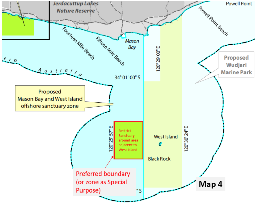
Mason Bay:
Whilst I understand the desire to protect the area immediately around West Island (within the
Wudjari Park), I don’t see the need for the proposed Mason Bay Sanctuary Zone especially in
deeper water and stretching out into 70+m. This is not adequatley explained or justified in the
documents provided.
Objectives would be achieved with a smaller area focused around West Island. Aside from
foraging pinnipeds (which are not impacted by recreational fishing according to your
assessment) it is unlikely that seagrass, sea dragons etc will be present in 70m+ of water.
This area is just out from Mason Bay campground and is very popular with people launching
small boats to fish. As a sanctuary Zone it will either force those people to travel larger
distances in small boats which could pose a safety risk or simply push them to other areas,
increasing the pressure. The impacts on adjacent areas are not fully understood since a proper
impact assessment has not been conducted.
The permitted activities within the proposed sanctuary zone are inconsistent with the objective
which is to protect seagrass, limestone reef, soft-sediment communities, Seals and sea lions.
As for other zones, recreational fishing is highly unlikely to have any measurable impact on
the listed receptors and certainly less so than activities which are permitted in a sanctuary
zone.
Proposed Modifications (see map 4):
• Either rezone as Special Purpose to allow recreational fishing or drastically shrink the
zone to an area immediately west of West Island.
0 Comments